Did you know?
Slipdown Mountain,
at an height of 1,368 feet above sea level, is the highest point in Parker County. It is located just east of Advance, in northern Parker County.
Kaliche Mountain
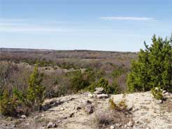
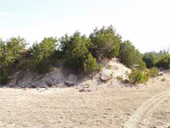
Kaliche Mountain is a finger off of the central ridge that goes through Parker County. Its tip is shaped like a four-pointed star. At a height of 1,118 feet above sea level, there is an awesome view from the top. It was named Kaliche Mountain because, years ago, the county dug caliche from it for use as road material. There are about 3 levels to the "mountain." The top is flat and bare, with only limestone rock and cedar trees.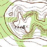
As you look out across Parker County from Kaliche Mountain, you can see for miles. Just a mile north of the poor farm, you can see the Home Depot. Much farther south is Comanche Peak in Hood County, which some have been able to spot from Kaliche Mountain. Although not truly an independent hill or mountain, Kaliche Mountain does rise high above the valley. You sure wouldn't want to fall off the edge!
 Jim Webster has built a road to the top of the mountain, so you can easily drive up there. There are plans for a pavilion and picnic tables on the top, as well as a hiking trail going all around the mountain. There is also an amphitheater planned, between two points of the star. As you can see from the topographical map, Kaliche Mountain is the very tip of a finger of the ridge.
< Back to the Nature page